
Trace an Atascocita Street by Address
Atascocita is an unincorporated Harris County community, so the useful address trail is county-centered. Start with the physical address in the Harris County Appraisal District, known as HCAD. Its account establishes the appraised owner display, situs address, tax mailing address, legal description, and map references. That is a property record, not a household roster. Continue with the map and deed index only after recording the account and legal description exactly. A street directory search can show a chain of records tied to an address, while the role shown in each record must stay clear.
- Search the HCAD property search by address. Save the account number, situs address, owner display, tax mailing address, and legal description.
- Open the parcel in the HCAD Parcel Viewer or Harris County GIS. Check the parcel shape, road frontage, subdivision, and nearby account links.
- Use the legal description in the Harris County Clerk Real Property Inquiry. Search the grantee, subdivision, lot, block, date, or instrument fields as the record supports.
- Read the deed image or order the appropriate copy. The seller named in a purchase deed becomes a lead for an earlier grantee search on the same legal description.
- Use My Voter Portal only for an individual match with its required identifying inputs. For a covered historical address, library directories and census material may add a dated household clue.
Each stop answers a different question. HCAD supplies appraisal context, GIS supplies geometry, the Clerk supplies recorded instruments, and a historical source can add a time period. None of those sources turns a street-wide search into a complete list of present household members.
Use HCAD Fields on Atascocita Streets
The HCAD advanced search can narrow a street directory search without guessing at a full address. Property Street Name works with Beginning Street Number and Ending Street Number for a segment. The Similar Street Name option can expand a spelling variation. ZIP, legal description, key map, map facet, school district, category, building style, square-foot range, and sort controls can refine a broad result. HCAD says searches are case-insensitive and partial names work, but it also caps results at 3,001.
| HCAD field | Input | How it helps an address search |
|---|---|---|
| Property Street Name | Street text, with Similar Street Name option | Finds a named street while allowing a controlled spelling variation. |
| Beginning and Ending Street Number | Numeric range | Limits results to an approximate segment instead of an entire road. |
| Legal Description | Subdivision, section, lot, or block text | Links the street locator to the title-record key. |
| ZIP Code | Five digits | Narrows a broad street result, but does not prove CDP or jurisdiction. |
| Key Map or Map Facet | Map reference | Helps cross-check the property account against mapping records. |
The captured HCAD advanced-property search shows the field set used to narrow an Atascocita street directory query.
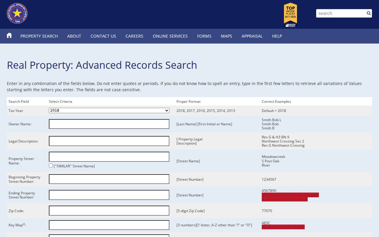
Use only the fields needed for the question. A number range and street name are a practical first pass; a legal description is the better bridge to a deed or plat.
HCAD advises trying address variants, omitting or changing a street type, using directional abbreviations, and allowing at least three days after a correction. Use the browser Back control when returning from a result. The service says mapping can lag the account, so an account result and a map pin should be compared rather than assumed identical.
Read Atascocita Address Fields Correctly
An HCAD account can show three separate ideas that are easy to blur together. The owner display is the appraisal record's owner name. The situs address is the physical parcel address. The mailing address is where tax notices go. A mailing address may belong to an entity office, representative, estate, or another city. A Humble postal line can also appear for a place commonly called Atascocita. Keep the account number and legal description with the result so a changed postal label does not detach the record from the parcel.
- Parcel
- A mapped piece of land tied to an appraisal account. Its boundary is approximate in GIS and is not a survey.
- Situs address
- The physical location used on an appraisal account. It can differ from a tax mailing address and use a Humble postal city.
- Plat
- A recorded subdivision map that connects roads to lot, block, section, or other legal-description terms.
- Criss-cross directory
- A street or householder arrangement used to look for historical address clues, rather than an alphabetical name list.
The HCAD property card can also provide values, exemptions, jurisdictions, characteristics, map references, sketches, and an ownership-history link where populated. A homestead exemption shows that an exemption was claimed; it does not establish present physical occupancy. HCAD also has a personal-information-removal form that can replace a displayed name with CURRENT OWNER on the public website, while the fuller record may remain available through a Public Information Act request.
Note: Treat an address and its appraisal fields as record-specific evidence, then seek a deed image when a property-transfer question needs proof.
Map Atascocita Street Parcel Geometry
GIS is the visual part of an Atascocita street directory search. The HCAD parcel service provides a polygon layer, while the consumer viewer is easier for selecting an address and viewing the surrounding parcels. On the map, identify the selected parcel, note its account and subdivision context, and compare its frontage with the adjacent polygons. The service can expose geometry and attributes, but its map boundaries are approximate. A shared edge may instead touch a road, drainage tract, commercial common area, or MUD parcel.
The current GIS documentation identifies bridge fields such as Vol_Page, RECNUM, Deed_Num, section, and subdivision. Those values can guide a follow-up in the Clerk index, but they do not replace the recorded image. The Harris County GIS address map draws on StarMap road and CenterPoint address data, and county GIS notes that exact dynamic map controls can change. Record the source date when comparing a property account to the map.
Move From an Atascocita Parcel to Deeds
The deed stage is where a street directory becomes a property-record trail. Copy the subdivision, lot, block, unit, tract, abstract, reserve, or other legal-description language from HCAD. In the Clerk's Real Property Inquiry, search the current owner as grantee and combine that name with the subdivision or other legal-description terms when useful. Date ranges and instrument type help focus the result. A grantor is the party transferring an interest; a grantee is the party receiving it. Those roles are not statements about current occupancy.
Harris County land records extend to 1836, but online document images begin November 1, 1960. The index is free. The Clerk describes copy, counter, mail, email, and annex routes for material that needs an official copy or older-book support. New documents can take one to two business days to appear. Before 1960, use the central-office microfilm or deed-book path rather than assuming the absence of an online image means no record exists.
The Harris County Clerk deed-index search includes grantor, grantee, trustee, date, legal-description, file, film, volume, and page routes for an Atascocita street directory search.
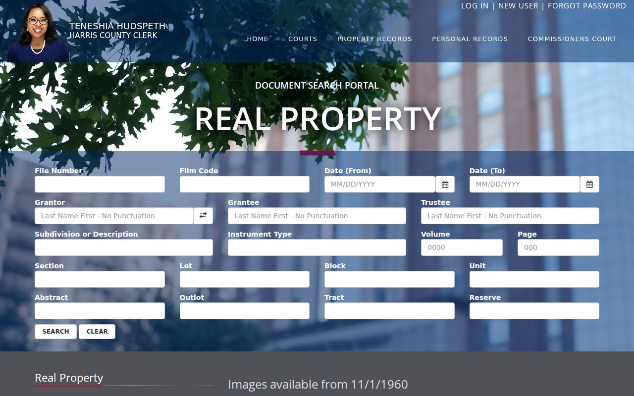
A result can identify party roles, instrument type, recording date, file or film code, volume and page, legal-description components, and image availability. Read related deeds, releases, restrictions, and plats separately when the legal description points to them.
Compare Atascocita Street Record Sources
Address-keyed sources do not all measure the same thing. HCAD is the practical starting point for an account and parcel. GIS places that account on a map. The Clerk's index supplies the recorded transfer and plat layer. Permits can date project activity, while voter and library sources have separate access rules. Pair the source with the question, then preserve the difference between a current appraisal field, a recorded instrument, and a dated historical clue.
| Address source | Custodian | Street-level value | Access route |
|---|---|---|---|
| Property account | HCAD | Owner display, situs, mailing, legal description, account, values, exemptions | Free web search |
| Parcel map | HCAD and Harris County GIS | Polygon, frontage, nearby parcels, map context, subdivision clues | Free viewer and map service |
| Recorded instruments and plats | Harris County Clerk | Grantor, grantee, deed, restriction, lot, block, subdivision, file references | Free index; copy channels may charge |
| Permit and inspection material | Harris County Office of County Engineer | Project or inspection timing tied to a permit or address record | Portal links, known permit number, or records request |
| Historical directories and census | HPL, HCPL, and federal repositories | Dated household or address clue for covered years | Library, database, scan, or archive access |
The street number is a locator, not the title-record key. The legal description carries the connection through a plat and recorded deed when the street type, postal city, or subdivision label changes.
Check Atascocita Permit Records by Number
The Harris County Office of County Engineer Civil Permits page is useful for a construction or development question, not for a broad street directory roster. It links to project status, documents, floodplain information, plat search, reporting, compliance, inspection, and ePermits. Development in unincorporated Harris County follows county permit rules, and the parcel should be checked in GIS before assuming a given address uses that route.
The publicly inspected ePermits request screen exposed a Permit Number field with a number-first path. It did not expose a general address or person search. When only an address is known, start with HCAD and GIS, identify the appropriate existing record, then use the OCE contact or a narrow Texas Public Information Act request for records the custodian maintains. A request should describe existing records and does not require an office to create a new street list.
Keep Atascocita Voter Searches Individual
Texas My Voter Portal is an individual-match service. Its name route uses Harris County with identifying information such as date of birth and ZIP, while other routes use VUID or Texas driver-license or ID information. A matched result can return registration status, polling place, precinct, and election information. It is not an ordinary screen for showing everyone on a street, and it does not reveal ballot choices.
A separate voter-file request is the route for authorized county or precinct data. It has a written-request and fee structure, may include status, address, and participation fields, and includes protected-voter exclusions. Texas Election Code section 18.009 prohibits use of furnished registration-list information for advertising or promoting commercial products or services. A no-match can reflect spelling, ZIP, recent movement, status, or a refresh issue, rather than proving a person never registered.
Find Historic Clues on Atascocita Streets
There is no located evidence of a continuous Atascocita reverse-directory run. For older address work, Houston Public Library street and householder sections, printed city-directory shelves, and address-reference assistance are the closest criss-cross substitutes. Their Houston-centered coverage matters: an absent Atascocita entry may reflect the collection's geography rather than the absence of a household. Search street-name and number variants, then pair a dated directory clue with deeds, plats, census schedules, or newspapers.
The HCPL Genealogy and History resources provide database and collection paths for census, voter lists, city-directory materials, newspapers, and Digital Sanborn Maps from 1867 through 1970. Sanborn coverage should never be assumed for an Atascocita subdivision. When the goal shifts from a modern street segment to historical directory volumes, the Atascocita city directory collection routes offer the focused historical approach.
Note: Harris County's record story combines digital access with older microfilm and deed-book methods, so date coverage should be checked before relying on a search result.
Respect Limits of an Atascocita Street Directory
A public address record may identify an appraisal owner, a tax recipient, a party to a deed, or a dated directory entry. It may not identify every person at an address. Private household members, utility customers, and protected motor-vehicle information are not public street-search material. Texas Address Confidentiality Program participants and protected voters can have address information suppressed. Do not republish sensitive details from an old document image, even when a record is available through a custodian.
Lawful use. Use Atascocita address records for personal, lawful research and record verification. Texas Penal Code sections 42.07 and 42.072 address harassment and stalking; never use a record trail to watch, threaten, or intimidate anyone.
The HCAD removal process, protected-voter procedures, and the Texas Address Confidentiality Program are different remedies for different records. A missing public display does not authorize attempts to reconstruct a protected address from other sources.